remote sensing

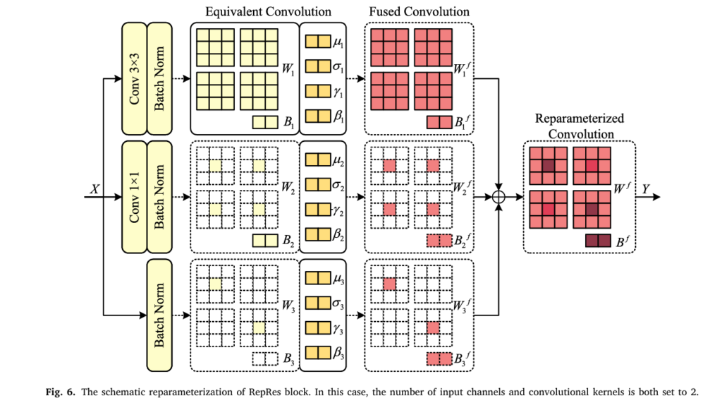
RepVIS-GAN: Nighttime Satellite Visible Image Retrieval from Infrared Data.

RepVIS-GAN: Nighttime Satellite Visible Image Retrieval from Infrared Data

RepVIS-GAN: Nighttime Satellite Visible Image Retrieval from Infrared Data | AI Trend Blend AITrendBlend Machine Learning Computer Vision About Satellite AI · ISPRS Journal of Photogrammetry and Remote Sensing 236 (2026) 162–174 · 20 min read RepVIS-GAN: Teaching a Satellite to See in the Dark by Reading the Heat It Can Already Feel Every night, […]

RepVIS-GAN: Nighttime Satellite Visible Image Retrieval from Infrared Data Read More »
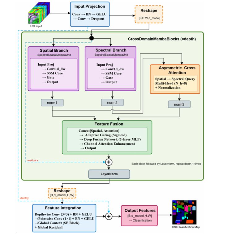
SSA-Mamba: The Hyperspectral Classifier That Finally Lets Spatial and Spectral Features Talk to Each Other

SSA-Mamba: The Hyperspectral Classifier That Finally Lets Spatial and Spectral Features Talk to Each Other

SSA-Mamba: The Hyperspectral Classifier That Finally Lets Spatial and Spectral Features Talk to Each Other | AI Trend Blend AITrendBlend Machine Learning Computer Vision About Remote Sensing AI · IEEE JSTARS, Vol. 19, 2026 · DOI: 10.1109/JSTARS.2026.3654346 · 22 min read SSA-Mamba: The Hyperspectral Classifier That Finally Lets Spatial and Spectral Features Talk to Each

SSA-Mamba: The Hyperspectral Classifier That Finally Lets Spatial and Spectral Features Talk to Each Other Read More »

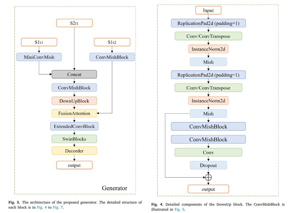
CRGenNet: Cloud-Free Optical Image Generation Using SAR and Contaminated Optical Data.

CRGenNet: Cloud-Free Optical Image Generation Using SAR and Contaminated Optical Data

CRGenNet: Cloud-Free Optical Image Generation Using SAR and Contaminated Optical Data | AI Trend Blend AITrendBlend Machine Learning Computer Vision About Remote Sensing AI · ISPRS Journal of Photogrammetry and Remote Sensing 236 (2026) 255–272 · 22 min read CRGenNet: How Satellites Can See Through Clouds by Never Assuming the Sky Is Clear Researchers at

CRGenNet: Cloud-Free Optical Image Generation Using SAR and Contaminated Optical Data Read More »

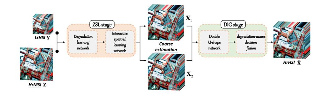
EDIP-Net: Enhanced Deep Image Prior for Unsupervised Hyperspectral Super-Resolution.

EDIP-Net: Enhanced Deep Image Prior for Unsupervised Hyperspectral Super-Resolution

EDIP-Net: Enhanced Deep Image Prior for Unsupervised Hyperspectral Super-Resolution | AI Trend Blend AITrendBlend Machine Learning Computer Vision About Remote Sensing · Hyperspectral AI · IEEE Transactions on Geoscience and Remote Sensing, Vol. 63 (2025) · 20 min read EDIP-Net: What Happens When You Stop Feeding Random Noise to Deep Image Prior Researchers at the

EDIP-Net: Enhanced Deep Image Prior for Unsupervised Hyperspectral Super-Resolution Read More »

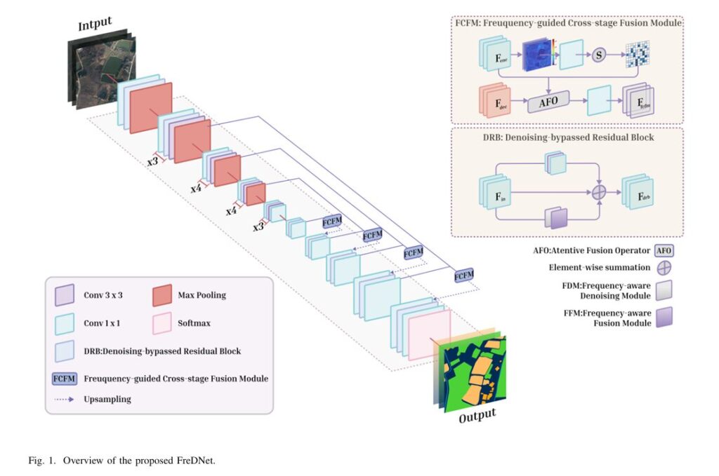
Overview of the proposed FreDNet.

FreDNet: The Remote Sensing Segmenter That Learned to Hear the Image, Not Just See It

FreDNet: The Remote Sensing Segmenter That Learned to Hear the Image, Not Just See It AITrendBlend Computer Vision About Remote Sensing AI · IEEE Trans. Geoscience & Remote Sensing, Vol. 64, 2026 · 22 min read The Segmentation Model That Learned to Hear the Image, Not Just See It Researchers at Hohai University built a

FreDNet: The Remote Sensing Segmenter That Learned to Hear the Image, Not Just See It Read More »

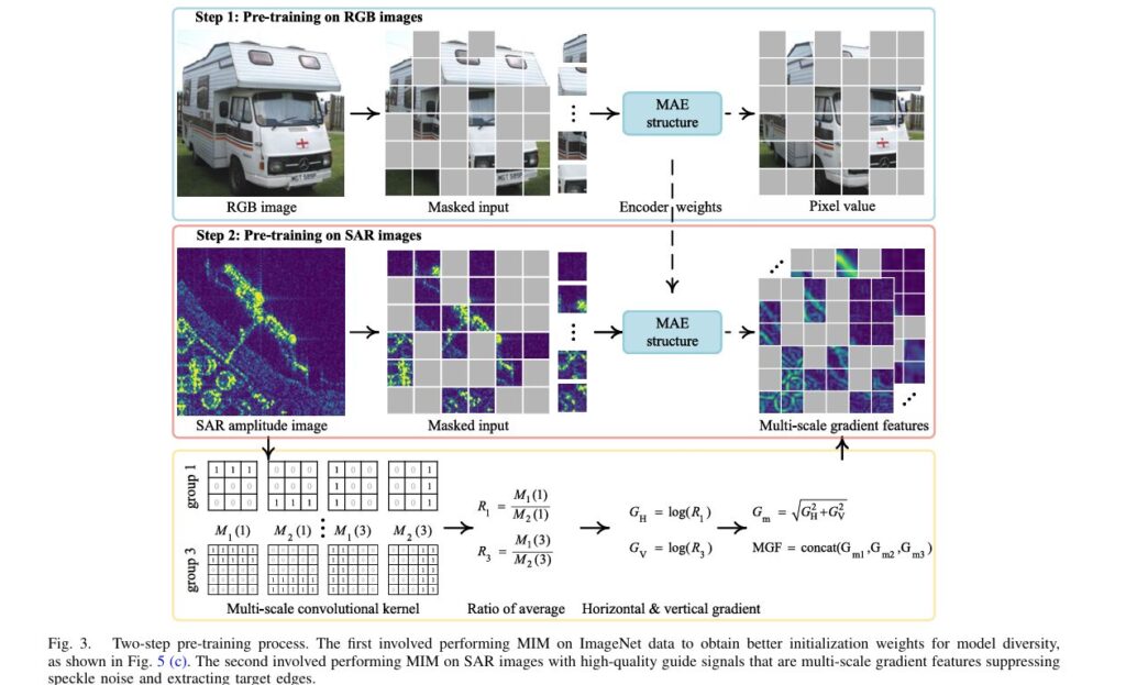
SARATR-X: Revolutionary Foundation Model Transforms SAR Target Recognition with Self-Supervised Learning

SARATR-X: Revolutionary Foundation Model Transforms SAR Target Recognition with Self-Supervised Learning

Introduction: Breaking New Ground in Radar Image Analysis Imagine a technology that can see through clouds, darkness, and adverse weather conditions to identify vehicles, ships, and aircraft with remarkable precision. This is the power of Synthetic Aperture Radar (SAR), and now, researchers have developed SARATR-X—the first foundation model specifically designed to revolutionize how machines understand

SARATR-X: Revolutionary Foundation Model Transforms SAR Target Recognition with Self-Supervised Learning Read More »

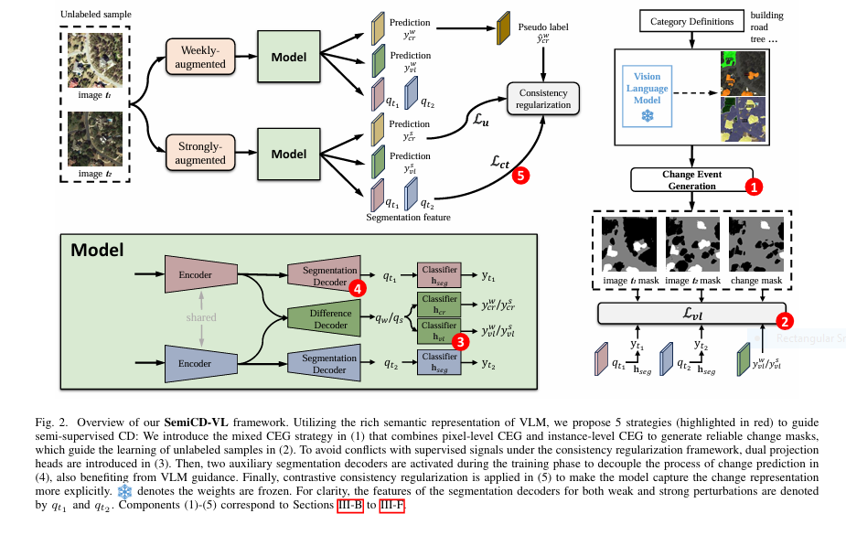
SemiCD-VL architecture overview showing VLM guidance, dual projection heads, and contrastive regularization.

Revolutionize Change Detection: How SemiCD-VL Cuts Labeling Costs 5X While Boosting Accuracy

Change detection—the critical task of identifying meaningful differences between images over time—just got a seismic upgrade. For industries relying on satellite monitoring (urban planning, disaster response, agriculture), pixel-level annotation has long been the costly, time-consuming bottleneck stifling innovation. But a breakthrough AI framework—SemiCD-VL—now slashes labeling needs by 90% while delivering unprecedented accuracy, even outperforming fully supervised models. The Crippling

Revolutionize Change Detection: How SemiCD-VL Cuts Labeling Costs 5X While Boosting Accuracy Read More »

Follow by Email
Tiktok