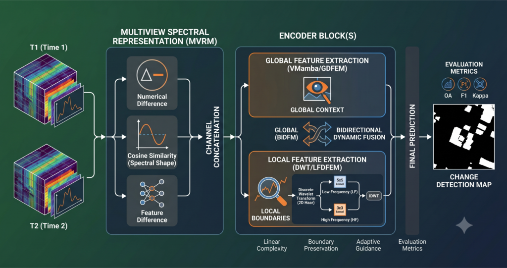
Remote Sensing AI

Machine learning for satellite and aerial imagery: hyperspectral and multispectral fusion, change detection, and multi-sensor pipelines. Coverage focuses on what makes these methods reliable when the sensors disagree and the scenes change.

Railway Sinkhole Detection with Physics-Informed Synthetic Data and SuperPoint Transformer.

Railway Sinkhole Detection with Physics-Informed Synthetic Data and SuperPoint Transformer

Railway Sinkhole Detection with Physics-Informed Synthetic Data and SuperPoint Transformer | AI Trend Blend AITrendBlend Machine Learning Computer Vision Engineering AI About Infrastructure AI · ISPRS Journal of Photogrammetry and Remote Sensing 236 (2026) 487–499 · 21 min read How French Railway Engineers Taught an AI to Find Sinkholes It Had Almost Never Seen Before

Railway Sinkhole Detection with Physics-Informed Synthetic Data and SuperPoint Transformer Read More »

RepVIS-GAN: Nighttime Satellite Visible Image Retrieval from Infrared Data.

RepVIS-GAN: Nighttime Satellite Visible Image Retrieval from Infrared Data

RepVIS-GAN: Nighttime Satellite Visible Image Retrieval from Infrared Data | AI Trend Blend AITrendBlend Machine Learning Computer Vision About Satellite AI · ISPRS Journal of Photogrammetry and Remote Sensing 236 (2026) 162–174 · 20 min read RepVIS-GAN: Teaching a Satellite to See in the Dark by Reading the Heat It Can Already Feel Every night,

RepVIS-GAN: Nighttime Satellite Visible Image Retrieval from Infrared Data Read More »

Mask-CDKD: Source-Free Knowledge Distillation from SAM for Satellite Onboard Land Cover Mapping.

Mask-CDKD: Source-Free Knowledge Distillation from SAM for Satellite Onboard Land Cover Mapping

Mask-CDKD: Source-Free Knowledge Distillation from SAM for Satellite Onboard Land Cover Mapping | AI Trend Blend AITrendBlend Machine Learning Computer Vision About Satellite AI & Remote Sensing · ISPRS J. Photogramm. Remote Sens. 236 (2026) 1–21 · Wuhan University / Emory · 28 min read Teaching a Satellite to See the World Without Labels: How

Mask-CDKD: Source-Free Knowledge Distillation from SAM for Satellite Onboard Land Cover Mapping Read More »

Causal Graph Neural Networks for Wildfire Forecasting Across Geographic Shifts.

Causal Graph Neural Networks for Wildfire Forecasting Across Geographic Shifts

Causal Graph Neural Networks for Wildfire Forecasting Across Geographic Shifts | AI Trend Blend AITrendBlend Machine Learning Computer Vision About Earth Observation & Climate AI · ISPRS J. Photogramm. Remote Sens. 236 (2026) 654–667 · TU Munich / NOA Athens · 27 min read Why Your Wildfire Forecast Fails in Europe When It Was Trained

Causal Graph Neural Networks for Wildfire Forecasting Across Geographic Shifts Read More »

MeCSAFNet: Dual-Branch ConvNeXt for Multispectral Semantic Segmentation.

MeCSAFNet: Dual-Branch ConvNeXt for Multispectral Semantic Segmentation

MeCSAFNet: Dual-Branch ConvNeXt for Multispectral Semantic Segmentation | AI Trend Blend AITrendBlend Machine Learning Computer Vision About Remote Sensing AI · Neurocomputing 685 (2026) 133533 · 22 min read Seeing Every Wavelength at Once: How MeCSAFNet Rewires Multispectral Segmentation Researchers at Universitat Autònoma de Barcelona built a dual-branch ConvNeXt network that separates visible and non-visible

MeCSAFNet: Dual-Branch ConvNeXt for Multispectral Semantic Segmentation Read More »

ViRefSAM: How Visual Reference Images Are Finally Making SAM Work for Remote Sensing.

ViRefSAM: How Visual Reference Images Are Finally Making SAM Work for Remote Sensing

ViRefSAM: How Visual Reference Images Are Finally Making SAM Work for Remote Sensing | AI Trend Blend AITrendBlend Machine Learning Computer Vision About Computer Vision · arXiv:2507.02294 · Remote Sensing & Foundation Models · 20 min read ViRefSAM: Teaching SAM to Segment Anything in Satellite Imagery — Without You Drawing a Single Box Researchers from

ViRefSAM: How Visual Reference Images Are Finally Making SAM Work for Remote Sensing Read More »

SSA-Mamba: The Hyperspectral Classifier That Finally Lets Spatial and Spectral Features Talk to Each Other

SSA-Mamba: The Hyperspectral Classifier That Finally Lets Spatial and Spectral Features Talk to Each Other

SSA-Mamba: The Hyperspectral Classifier That Finally Lets Spatial and Spectral Features Talk to Each Other | AI Trend Blend AITrendBlend Machine Learning Computer Vision About Remote Sensing AI · IEEE JSTARS, Vol. 19, 2026 · DOI: 10.1109/JSTARS.2026.3654346 · 22 min read SSA-Mamba: The Hyperspectral Classifier That Finally Lets Spatial and Spectral Features Talk to Each

SSA-Mamba: The Hyperspectral Classifier That Finally Lets Spatial and Spectral Features Talk to Each Other Read More »