Remote Sensing AI

Machine learning for satellite and aerial imagery: hyperspectral and multispectral fusion, change detection, and multi-sensor pipelines. Coverage focuses on what makes these methods reliable when the sensors disagree and the scenes change.

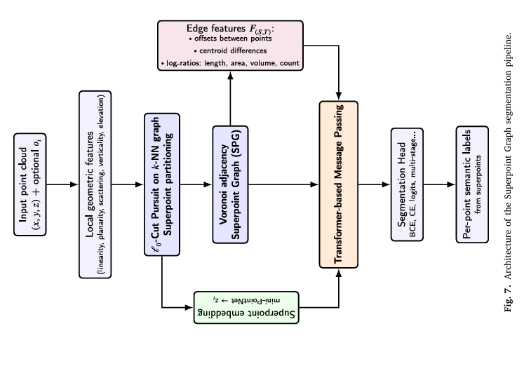
Railway Sinkhole Detection with Physics-Informed Synthetic Data and SuperPoint Transformer.

Railway Sinkhole Detection with Physics-Informed Synthetic Data and SuperPoint Transformer

When you only have a handful of real sinkhole examples, you either accept poor detection or get creative about generating training data. Researchers at Arts et Métiers ParisTech and SNCF Réseau chose the latter — building physics-informed synthetic sinkholes, embedding…

Railway Sinkhole Detection with Physics-Informed Synthetic Data and SuperPoint Transformer Read More »

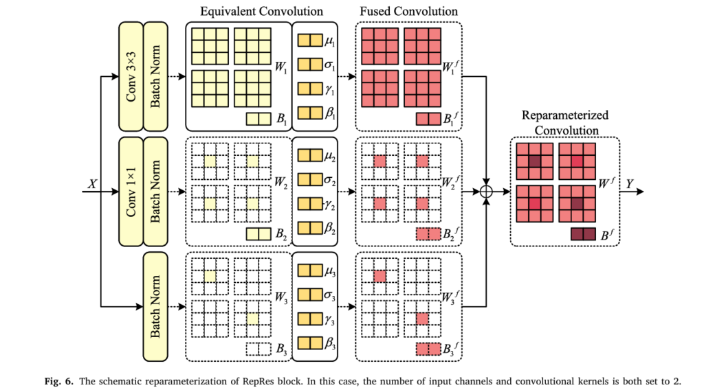
RepVIS-GAN: Nighttime Satellite Visible Image Retrieval from Infrared Data.

RepVIS-GAN: Nighttime Satellite Visible Image Retrieval from Infrared Data

Every night, weather satellites go partially blind — their visible cameras shut off the moment the sun dips below the horizon. Researchers at Ocean University of China built a reparameterized GAN that reads three thermal infrared channels and reconstructs what…

RepVIS-GAN: Nighttime Satellite Visible Image Retrieval from Infrared Data Read More »

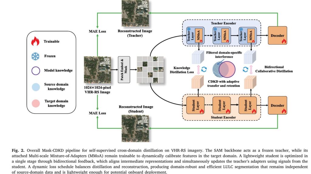
Mask-CDKD: Source-Free Knowledge Distillation from SAM for Satellite Onboard Land Cover Mapping.

Mask-CDKD: Source-Free Knowledge Distillation from SAM for Satellite Onboard Land Cover Mapping

Researchers at Wuhan University built a distillation framework that transfers SAM’s powerful visual priors to a compact student network using only unlabeled satellite imagery — no source data, no labels — and deployed the result live on an edge AI…

Mask-CDKD: Source-Free Knowledge Distillation from SAM for Satellite Onboard Land Cover Mapping Read More »

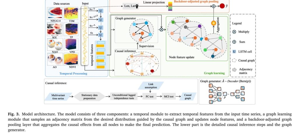
Causal Graph Neural Networks for Wildfire Forecasting Across Geographic Shifts.

Causal Graph Neural Networks for Wildfire Forecasting Across Geographic Shifts

Shan Zhao, Ioannis Prapas, and their colleagues at TU Munich and the National Observatory of Athens built a causally informed graph neural network that forecasts burned areas with 64% lower prediction variance and outperforms correlation-based baselines by 2–5 AUROC points…

Causal Graph Neural Networks for Wildfire Forecasting Across Geographic Shifts Read More »

MeCSAFNet: Dual-Branch ConvNeXt for Multispectral Semantic Segmentation.

MeCSAFNet: Dual-Branch ConvNeXt for Multispectral Semantic Segmentation

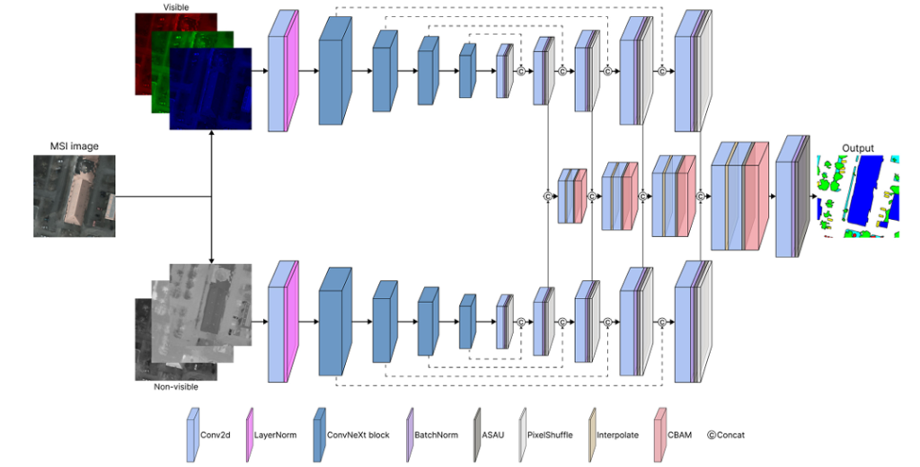
Researchers at Universitat Autònoma de Barcelona built a dual-branch ConvNeXt network that separates visible and non-visible spectral information, fuses them with CBAM attention, and maps land cover at accuracy levels that leave U-Net, SegFormer, and DeepLabV3+ behind — without needing…

MeCSAFNet: Dual-Branch ConvNeXt for Multispectral Semantic Segmentation Read More »

ViRefSAM: How Visual Reference Images Are Finally Making SAM Work for Remote Sensing.

ViRefSAM: How Visual Reference Images Are Finally Making SAM Work for Remote Sensing

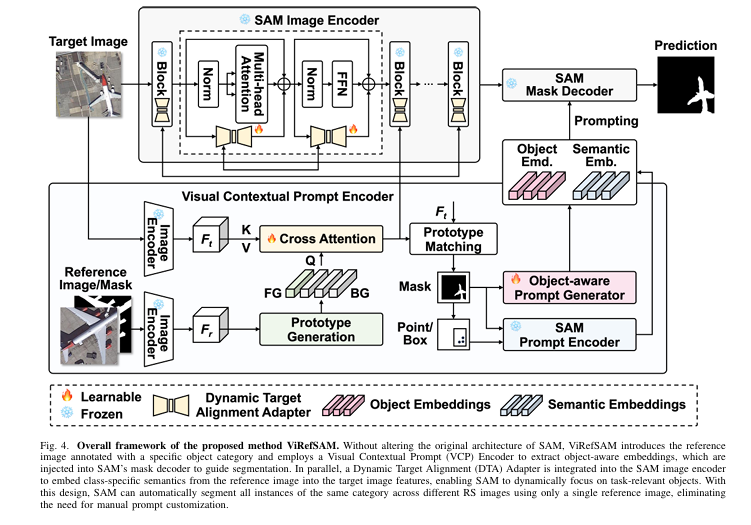
Researchers from the Chinese Academy of Sciences built a framework that feeds a handful of annotated reference images into SAM’s pipeline, eliminating the need to manually prompt each aerial scene — and in the process, achieved state-of-the-art few-shot segmentation across…

ViRefSAM: How Visual Reference Images Are Finally Making SAM Work for Remote Sensing Read More »

SSA-Mamba: The Hyperspectral Classifier That Finally Lets Spatial and Spectral Features Talk to Each Other

SSA-Mamba: The Hyperspectral Classifier That Finally Lets Spatial and Spectral Features Talk to Each Other

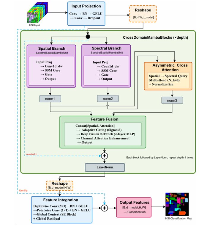
Researchers at Guangzhou Maritime University diagnosed a fundamental flaw in every existing hyperspectral classification model — spatial and spectral features are either forced to share the same representation space, or kept so separate they never productively interact. SSA-Mamba fixes both…

SSA-Mamba: The Hyperspectral Classifier That Finally Lets Spatial and Spectral Features Talk to Each Other Read More »

GLMamba: How Global-Local Mamba Detects Change in Satellite Images Better Than CNNs and Transformers.

GLMamba: How Global-Local Mamba Detects Change in Satellite Images Better Than CNNs and Transformers

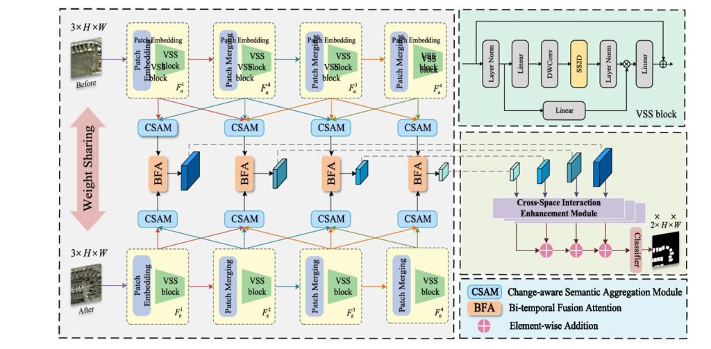
Shengyan Liu and Min Xia at NUIST introduce GLMamba: a Siamese Mamba network that pairs global state-space modeling with local convolutional detail extraction for remote sensing change detection. On LEVIR-CD it posts F1=91.27% and IoU=83.94%, outperforming ChangeMamba, ChangeFormer, and nine…

GLMamba: How Global-Local Mamba Detects Change in Satellite Images Better Than CNNs and Transformers Read More »

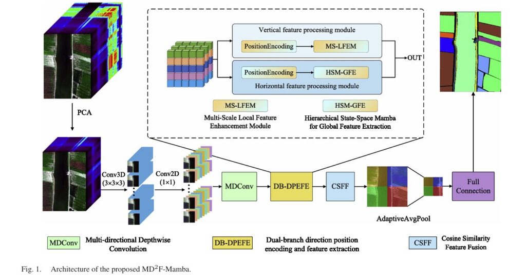
MD2F-Mamba: How Directional Convolution and Dual-Branch Mamba Crack Hyperspectral Image Classification.

MD2F-Mamba: How Directional Convolution and Dual-Branch Mamba Crack Hyperspectral Image Classification

Xiaoqing Wan and colleagues at Hengyang Normal University introduce MD2F-Mamba: a dual-branch architecture pairing multidirectional depthwise convolution with a hierarchical state-space Mamba for hyperspectral classification. With just 92K parameters and 8.3M FLOPs, it posts 99.81% overall accuracy on Pavia University…

MD2F-Mamba: How Directional Convolution and Dual-Branch Mamba Crack Hyperspectral Image Classification Read More »